To Tuck Into a Stocking: A Portal to Dreams of NYC

To Tuck Into a Stocking: A Portal to Dreams of NYC
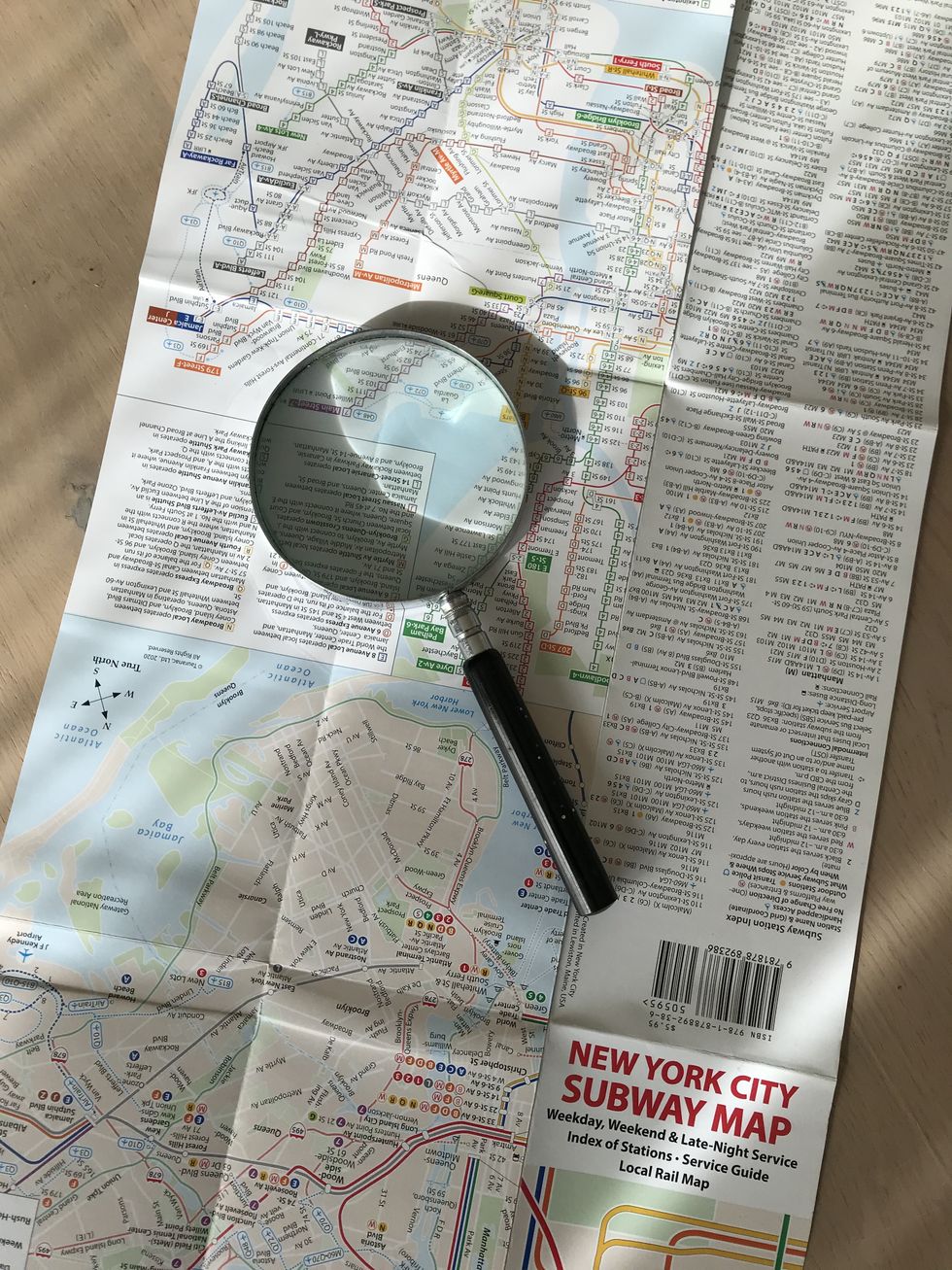
John Tauranac, designer of the iconic New York City subway map, has a new and improved map that he is selling at retail outlets, including the Wish House in West Cornwall. Photo by Cynthia Hochswender

Mapmaker John Tauranac (a part-time resident of Cornwall, Conn.) has taken the iconic New York City subway map (which he designed) and made it, if possible, even a little better. 

This new version, published in August, is published by Tauranac Maps and can be purchased locally at The Wish House in West Cornwall, Conn. (www.wishhouse.com) for $5.95. 

When Tauranac, a Cornwall, Conn., resident and a fairly low key gent, was asked if it lives up to its billing as “ultimate subway map,” he modestly confessed, “I am so vain as to believe that it is.” 

The very first New York subway map was produced in 1904 as an advertising postcard issued by Wanamaker’s Department Store in Manhattan, which could be accessed by a subway station stop on its lower level.

Many map iterations followed, but it was the 1979 version that introduced the concept of color coding the subway lines. 

Tauranac was already achieving acclaim for his 1972 and 1973 “undercover maps” of Midtown and Lower Manhattan, tracing the underground walking passages that thread through and under the city’s buildings. 

He was employed by the MTA (Metropolitan Transit Authority) and in 1974 was working on creating an official travel guide and introducing a geographically accurate subway map.  

By 1978, he was the chairman of the MTA subway map committee but had been unsuccessful in gaining approval for his ideas for the color-coding system. 

That same year, though, bolstered by the support of socialite and powerhouse Phyllis Cerf Wagner, Tauranac’s concept of the quasi-geographic, color-coded system was approved by the MTA president.

The 1979 MTA map has provided the bones for all subsequent maps, Tauranac said. But with each new edition, the map has incorporated changes that render it more confusing.

Tauranac’s new MTA pocket map pack is self-published and conveys even more information in a clearer, color-coded and keyed presentation. For example,there is now a separate map on the reverse side with information about late-night service. 

For any riders who have ever discovered that they were traveling north on a line when they meant to go south, Tauranac has added a no u-turn symbol to indicate stations where riders cannot cross the tracks without paying to go the other way. If you don’t see the symbol, you can use that station to correct your directional error.

The new map also answers the question of where the subway station is in relation to a station stop, particularly helpful when avenues are positioned diagonally to the normal street grid. To promote clarity, Tauranac explains that exercising geographic license makes the map “quasi-geographic.”

With the aid of a key guide printed at the top of the map, riders can tell a lot about a station by the color, its intensity and the geometric shape representing the subway line.  

Access for handicapped riders is noted with a visual cue — although Tauranac notes that ease-of-access information is also helpful for riders with luggage or baby strollers. 

For the first time, there is an index of stations within the subway system, with bus connections noted for each station, for example.

As for where the lifelong interest in the details of New York City transit and architecture began, Tauranac credits his childhood years when his father, who was the manager of a major hotel, took him on regular city walks in the 1960s. 

Tauranac’s mother had died when he was very young, so these walks with his father were especially important. His father would often pause to point out who lived where along Fifth Avenue, for example.  

“It sort of stuck,” Tauranac said.

To put together a more substantial gift of New York City lore, there are additional Tauranac works that offer a deep look into the city and what lies beneath its surface, including a poster version of the new map.

Although all authors love all their books, as parents love their children, Tauranac was especially pleased with a review of one of his books, from the New York Times. About “Manhattan Block By Block: A Street Atlas,” the paper said, it “offers just about all the critical information a site-seeker might need — and then some.’”

Sometimes more is more. 


To find out about John Tauranac’s books and insights into New York City, go to his website at www.johntauranac.com.

Related Articles Around the Web

Latest News

Water main break disrupts downtown Sharon

Crews work on a broken water main on the town Green in Sharon on Sunday, Feb. 1.

Ruth Epstein

SHARON — A geyser erupted on the town Green Friday afternoon, Jan. 30, alerting officials to a water main break in the adjacent roadway. Repair crews remained on site through the weekend to fix the damaged line.

About 15 nearby homes lost water service Friday while crews made repairs. Water was restored by Sunday afternoon. The water system is overseen by the town’s Sewer and Water Commission.

Keep ReadingShow less
Hayes tours new affordable home in recent visit to Salisbury

John Harney, president of the Salisbury Housing Trust, presents Jocelyn Ayer, executive director of the Litchfield County Centers for Housing Opportunity, center, and U.S. Rep. Jahana Hayes, 5th District, with local maple syrup. Hayes was in Salisbury Thursday to tour one of the trust’s latest houses on Perry Street.

Ruth Epstein

SALISBURY — Congresswoman Jahana Hayes (D-5) admired the kitchen cabinets, the sunlight streaming through the large windows and an airy room well suited for flexible living space.

She toured the new affordable home at 17 Perry St. on Thursday, Jan. 29. The house, recently completed by the Salisbury Housing Trust, is awaiting a family to call it home. The modular home is one of four erected in Salisbury through the Litchfield County Center for Housing Opportunity’s Affordable Homeownership Program for scattered sites. Houses were also built in Norfolk, Cornwall and Washington.

Keep ReadingShow less
Judge throws out zoning challenge tied to Wake Robin Inn expansion

A judge recently dismissed one lawsuit tied to the proposed redevelopment, but a separate court appeal of the project’s approval is still pending.

Alec Linden

LAKEVILLE — A Connecticut Superior Court judge has dismissed a lawsuit filed against Salisbury’s Planning and Zoning Commission challenging a zoning amendment tied to the controversial expansion of the Wake Robin Inn.

The case focused on a 2024 zoning regulation adopted by the P&Z that allows hotel development in the Rural Residential 1 zone, where the historic Wake Robin Inn is located. That amendment provided the legal basis for the commission’s approval of the project in October 2025; had the lawsuit succeeded, the redevelopment would have been halted.

Keep ReadingShow less
A winter visit to Olana

Olana State Historic Site, the hilltop home created by 19th-century Hudson River School painter Frederic Edwin Church, rises above the Hudson River on a clear winter afternoon.

By Brian Gersten

On a recent mid-January afternoon, with the clouds parted and the snow momentarily cleared, I pointed my car northwest toward Hudson with a simple goal: to get out of the house and see something beautiful.

My destination was the Olana State Historic Site, the hilltop home of 19th-century landscape painter Frederic Edwin Church. What I found there was not just a welcome winter outing, but a reminder that beauty — expansive, restorative beauty — does not hibernate.

Keep ReadingShow less