Recovery underway after July 4 storms devastate Northwest Corner

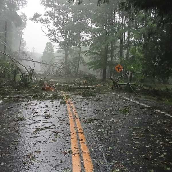
Ben Blackwell directs traffic in Salisbury as motorists navigate road closures caused by fallen trees.
Patrick L. Sullivan


This is a developing story.
After a series of extreme storms pummeled the Northwest Corner late July 4, communities are picking up the pieces and offering support to those affected by blocked roads, downed power lines, and power and water outages.
Clean-up efforts may be impacted by approaching heavy rain and storms late Sunday afternoon through Tuesday. Litchfield County is under a flash flood watch from the National Weather Service, which predicted two to four inches of rainfall for the region, with local amounts possibly exceeding five inches. Excessive rainfall is expected to be the primary risk through the early week rather than wind or hail.
As of Sunday morning, July 5, many roads throughout northwest Connecticut remained closed and more than 70,000 Eversource customers in the state were left without power. Salisbury and Falls Village bore the brunt of the damage, with residents referring to the scene as “apocalyptic.”
The Town of Canaan (Falls Village) declared a local State of Emergency as a result of the storm damage. First Selectman David Barger said the move could help relieve the financial burden of the storm if state or federal funds become available.
“We want to be able to utilize all of our resources,” Barger said, adding that town crews have been called in for overtime hours to support the clean-up. He said he received calls from North Canaan and Kent town officials who offered their support.
“Whether it be with the volunteer fire departments or the department of public works, they stand ready to help us,” he said. “The towns in Region One have really been drawn together with some common problems and common initiatives, and this is one of those things where we’re all working together.”
Salisbury, Cornwall, Goshen, Harwinton and Torrington each declared a local State of Emergency as of 2 p.m. Sunday, Litchfield County Dispatch Supervisor Ryan Ptakowski said.
As of early Sunday afternoon, state police at Troop B in North Canaan had not received reports of any injuries from the storms.
Officials in the region have asked residents to refrain from unnecessary travel as crews remove trees from roads and repair utility infrastructure.
 Lakeville residents Suzy Colpitt and her father, John, retrieve drinking water from a public water fountain near Salisbury Town Hall on Route 44.Nathan Miller
Power outages persist, officials say it could last ‘for days’
More than 70,000 Eversource customers were without power Sunday morning, although the number dropped to just over 66,000 by noon. Progress was slow in the Northwest Corner. In Salisbury, 93% of customers remained without power as of 1 p.m. Sunday, with 2,792 of 3,006 customers affected.
Falls Village was also heavily affected, with more than 50% of customers without power.
Just under 20% of Sharon residents were impacted, with 415 customers without power.
Gov. Ned Lamont said in a statement that repairs in certain areas could take days due to the scale of the damage.
“The utilities have called down additional crews from Canada to help restore power in Connecticut as soon as possible,” he said.
Sharon Hospital is up and running
Although Sharon Hospital lost power for a short period of time Saturday night, Supervisor Elizabeth Barrows said the emergency generators kicked on and services were not interrupted.
Griffin Cooper, who handles public and community affairs for the hospital, said the emergency room remains open Sunday and all services are operating as usual.
While Barrows could not confirm whether the storm resulted in any injuries, she said the hospital had seen a number of visits from patients who were unable to use their portable oxygen concentrators as a result of power loss. She said the Sharon Fire Department also has chairs set up for anyone who relies on oxygen and needs electricity to operate tanks.
High School to open gymnasium for families in need
Superintendent Melony Brady-Shanley announced Housatonic Valley Regional High School will open its gymnasium Monday, July 6, from 9 a.m. to 3 p.m. to offer a place for Region One families to charge phones, access drinking water or take a shower.
The high school also temporarily canceled all school activities, including camps, Extended School Year services, and other scheduled activities. Officials also asked all employees to stay home Monday and Tuesday and work remotely.
Brady-Shanley confirmed that all Region One local schools will remain closed Monday and Tuesday until further notice.
Labonne’s market in Salisbury closed until further notice
Rob LaBonne, owner of LaBonne’s market, announced the grocery store would be closed Sunday until further notice. With power lines down in the parking lot, he asked customers to avoid the area.
Although a few employees were expected to be on site Sunday to aid in the clean-up efforts, LaBonne did not provide an estimated timeline for reopening.
Electricians arrived in the middle of the night to help the market owner empty refrigerator cases and restore power through a generator.
“The town is absolutely devastated,” LaBonne wrote in a statement on Facebook. “Trees and powerlines are slashed in half. The whole town is without power.”
Sharon Farm Market and Stop and Shop in North Canaan remain open with regular business hours.
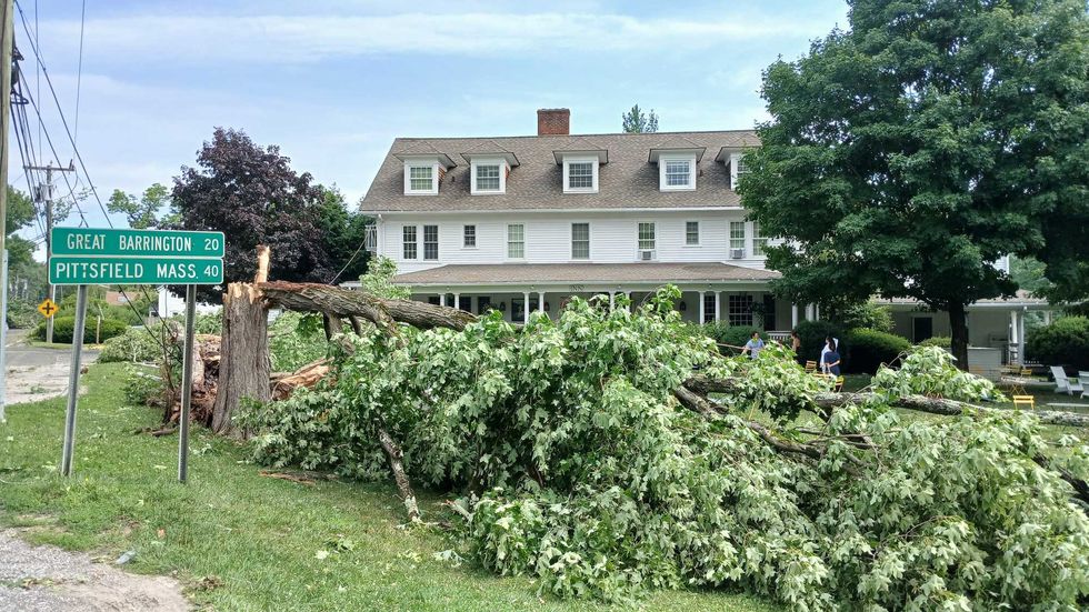 Fallen trees cover the lawn of the White Hart Inn, leaving the historic building obscured from the road. Patrick L. Sullivan
Strong winds, not tornado, likely responsible for damage, meteorologists say
Samantha Lankowicz, a meteorologist at the National Weather Service, said the most likely cause of the damage was strong winds.
“We looked over the radar and we didn’t see anything that would suggest there was a tornado – there were no strong signs of rotation,” Lankowicz said, adding that their radar did pick up strong, straight-line winds up to 60 and 70 miles per hour.
Although thunderstorms were predicted, most residents were not notified about the severity until shortly before the storm struck.
Bethel, Connecticut-based meteorologist Jack Drake, who provided real-time updates via social media throughout the storm window Saturday evening, told the Lakeville Journal on Sunday morning that forecasting difficulties in Litchfield County may have delayed warning of the storm’s destructive potential.
He said radar signatures indicated strong winds and hail as it entered Connecticut from New York, and that the storm was warned as severe about 30 minutes before impacting Salisbury, which is forecasting standard.
But the storm was upgraded to a “considerable damage tag,” an indicator the NWS uses for storms capable of producing golf ball-sized hail and 70-plus mile per hour winds, only after it had passed through Falls Village and was approaching Torrington. “It’s basically a severe thunderstorm warning-plus,” he said.
Drake said the storm traveled on a line from northwestern Salisbury southeast into Hartford County, describing it as a “classic discrete supercell” thunderstorm. He said it was one of the worst he’d seen in the region in recent years, bringing the largest hail since baseball-sized ice chunks fell during severe storms in 2018. He estimated based on damage that winds might have topped 80 miles per hour.
Drake noted that forecasting severe weather in the region, especially in summer when it is highly localized, is a challenge for meteorologists. “Litchfield County is a pretty big radar hole, in my opinion,” he said.
He said the holiday weekend may have contributed to the late warning, with a possible staffing shortage in the NWS Albany office, which had issued a “Level 2” or “Slight” risk of severe weather due to hot and humid atmospheric conditions primed for heavy thunderstorms.
Drake said that “risk-based” forecasting, which is how meteorologists predict for summer severe weather, can cause messaging issues to the public, since some storms, like yesterday's, may cause devastating impacts to one community but leave adjacent towns relatively untouched.
“The message is always just stay aware,” he said, encouraging residents to stay up to date, however possible, noting that social media has been a highly effective tool in the past two decades.
Flood risk issued for region
Further forecasted heavy rain and storms Sunday afternoon and overnight into Monday could impact recovery efforts and cause further damage, Drake said, predicting a general two to four inches of rain from the storm, with a 15%-40% risk of flash flooding for the region.


Karina Powers teaches traditional dances from Mexico in Millbrook.
Powers received a master’s degree in Mexican folklore dance from Escuela de la Danza in Baja California, Mexico. Since moving to the United States, she has built a career in performance and teaching. She has not only served as a dance director and performed as a professional vernacular music singer in California, but she has also worked towards her Doctorate, which she will receive in October.
As the founder of her company, Powers works tirelessly to make sure her dancers have everything they need, including costumes, proper flooring, music and a space to practice. Her husband built wooden panels, called tarimas, for students to dance on with their folklórico shoes. Millbrook Mayor Peter F. Doro allows Powers and her group to practice in Millbrook Hall, where she brings the tarimas to every practice along with costumes and proper footwear.
Powers dreams of owning her own studio where she can practice with her group, offer more classes, store costumes and create a space for her dancers to do their hair and makeup before performances. She said she hopes people learn about her classes so her company can grow and she can teach dances from a wider range of Mexican states while having greater access to traditional dress.
As a single mother and professor, Powers’ mother, Carmen Méndez, put her children in dance classes and signed them up for track and field, always keeping them goal- and career-oriented. She helped Powers with her company by creating all of the costumes her dancers wear in their performances. After her mother’s death in 2021, Powers said she has dedicated herself to carrying forward the passion, work ethic and love of dance her mother instilled in her.
“I miss her terribly, and I’m here because of her,” Powers said. “That’s why I want to do this, because of her. She gave me a lot, with the costumes, with her support. I do it for my mom.”
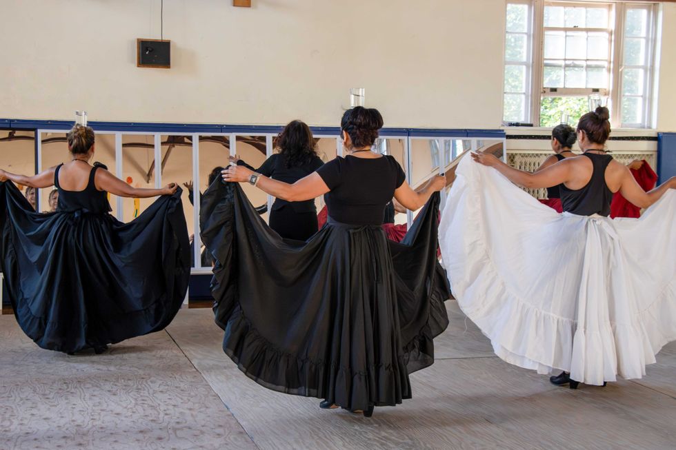 Karina Powers and her students practice in Millbrook Hall.Lucia Iandolo
Dancers in Powers’ group are dedicated to learning the art of dance from different states in Mexico on Tuesday and Friday nights at Millbrook Hall. They travel from many different places in New York to participate, with some dancers traveling more than an hour to make it to rehearsal each week.
“It’s a lot of work, but they learn it. I believe they love it, and it’s a way to come together, to do something good, to do something healthy, and to have people around you who appreciate this kind of art,“ Powers said.
Powers has studied with professor Eloy Jiménez Figueroa since childhood and said his mentorship inspired her to become the teacher she is today. She added that while she may not be the best teacher, she learned from the best.
While living in California, Powers taught elementary, high school and college students, as well as adults. She was recruited to teach traditional Mexican folkloric dance because of the region’s large Mexican community. Today, she encourages people of all backgrounds to explore the rich traditions of Mexican dance.
“This type of dance is not only for people from Mexico,” Powers said. “This is an art and the arts unite nations.”
Powers hopes to continue sharing that art in Millbrook and one day teach in the Millbrook Central School District. Powers and her group will perform at the Millbrook Library on Nov. 21, presenting traditional Mexican dances and inviting audience members to participate.
As a professor, dancer and singer, Powers stays grounded by believing in something greater than herself. She says that praying and putting herself in the hands of God has helped anchor her. She hopes to teach and dance for as long as her body allows.
“My mom, for me, is an angel. I put myself in her hands, and I have faith,” Powers said. “I have faith that God, or something good, is going to be there for the group and for myself.”


Want more of our stories on Google? Click here to make us a Preferred Source.