Latest News
Legal Notices - November 6, 2025
Nov 05, 2025
Legal Notice
The Planning & Zoning Commission of the Town of Salisbury will hold a Public Hearing on Special Permit Application #2025-0303 by owner Camp Sloane YMCA Inc to construct a detached apartment on a single family residential lot at 162 Indian Mountain Road, Lakeville, Map 06, Lot 01 per Section 208 of the Salisbury Zoning Regulations. The hearing will be held on Monday, November 17, 2025 at 5:45 PM. There is no physical location for this meeting. This meeting will be held virtually via Zoom where interested persons can listen to & speak on the matter. The application, agenda and meeting instructions will be listed at www.salisburyct.us/agendas/. The application materials will be listed at www.salisburyct.us/planning-zoning-meeting-documents/. Written comments may be submitted to the Land Use Office, Salisbury Town Hall, 27 Main Street, P.O. Box 548, Salisbury, CT or via email to landuse@salisburyct.us. Paper copies of the agenda, meeting instructions, and application materials may be reviewed Monday through Thursday between the hours of 8:00 AM and 3:30 PM at the Land Use Office, Salisbury Town Hall, 27 Main Street, Salisbury CT.
Salisbury Planning & Zoning Commission
Martin Whalen, Secretary
11-06-25
11-13-25
Notice of Decision
Town of Salisbury
Planning & Zoning Commission
Notice is hereby given that the following action was taken by the Planning & Zoning Commission of the Town of Salisbury, Connecticut on October 20, 2025:
8-24 referral was deemed consistent with the Plan of Conservation and Development - For the use of town-owned land at 20 Salmon Kill Road, Salisbury for housing, recreation, and conservation. The property is shown on Salisbury Assessor’s Map 11 as Lot 26.
Any aggrieved person may appeal these decisions to the Connecticut Superior Court in accordance with the provisions of Connecticut General Statutes §8-8.
Town of Salisbury
Planning &
Zoning Commission
Martin Whalen, Secretary
11-06-25
Notice of Decision
Town of Salisbury
Inland Wetlands & Watercourses Commission
Notice is hereby given that the following actions were taken by the Inland Wetlands & Watercourses Commission of the Town of Salisbury, Connecticut on October 27, 2025:
Exempt - Application IWWC-25-75 by Elaine Watson to install a 4’ by 45’ removable dock adjacent to the high-water mark of Lake Wononscopomuc. The property is shown on Salisbury Assessor’s map 47 lot 11 and is a vacant parcel located between 123 & 137 Sharon Road, across from and associated with 126 Sharon Road. The owners of the property are Paul and Elaine Watson.
Approved with the condition that any additional permits required for this project are filed with the Land Use Office - Application IWWC-25-74 by Richard Riegel, Principal of Lime Rock Park II, LLC to reinforce compromised river bank and implement riparian restoration in partnership with Trout Unlimited. The property is shown on Salisbury Assessor’s map 04 lot 16 and is known as 497 Lime Rock Road, Lakeville. The owner of the property is Lime Rock Park II, LLC.
Approved - Application IWWC-25-72 by George Johannesen of Allied Engineering Associates, Inc. for an addition to the existing house, construct garage, relocate driveway, landscaping. The property is shown on Salisbury Assessor’s map 08 lot 03 and is known as 396 Salmon Kill Road, Lakeville. The owners of the property are Randall Allen and Margaret Holden.
Approved subject to conditions recommended by the Town Consulting Engineer and the relinquishment of permit 2024-IW-036 - Application IWWC-25-69 by Bob Stair to construct an addition to the existing house and driveway in the upland review area. The property is shown on Salisbury Assessor’s map 67 lot 07 and is known as 300 Between the Lakes Road, Salisbury. The owner of the property is 280 BTLR LLC.
Approved subject to conditions recommended by the Town Consulting Engineer - Application IWWC-25-73 by Hotchkiss School (Michael J. Virzi) for a restoration plan for the existing temporary dining building at the Hotchkiss School. The property is shown on Salisbury Assessor’s map 06 lot 09 and is known as 22 Lime Rock Road, Lakeville. The owner of the property is Hotchkiss School.
Any aggrieved person may appeal this decision to the Connecticut Superior Court in accordance with the provisions of Connecticut General Statutes §22a-43(a) & §8-8.
11-06-25
NOTICE TO CREDITORS
ESTATE OF
DEBRA ANN WHITBECK
Late of North Canaan
(25-00419)
The Hon. Jordan M. Richards, Judge of the Court of Probate, District of Litchfield Hills Probate Court, by decree dated October 16, 2025, ordered that all claims must be presented to the fiduciary at the address below. Failure to promptly present any such claim may result in the loss of rights to recover on such claim.
The fiduciary is:
Donna L. Cooke
65 Orchard Street
North Canaan, CT 06018
Megan M. Foley
Clerk
11-06-25
NOTICE TO CREDITORS
ESTATE OF
THOMAS CROSBY DOANE
Late of North Canaan
(25-00388)
The Hon. Jordan M. Richards, Judge of the Court of Probate, District of Litchfield Hills Probate Court, by decree dated October 9, 2025, ordered that all claims must be presented to the fiduciary at the address below. Failure to promptly present any such claim may result in the loss of rights to recover on such claim.
The fiduciary is:
Jase Doane
5 Clearwater Lane
East Hampton, CT 06424
Megan M. Foley
Clerk
11-06-25
Keep ReadingShow less
Classifieds - November 6, 2025
Nov 05, 2025
Help Wanted
Weatogue Stables has an opening: for a full time team member. Experienced and reliable please! Must be available weekends. Housing a possibility for the right candidate. Contact Bobbi at 860-307-8531.
Services Offered
Deluxe Professional Housecleaning: Experience the peace of a flawlessly maintained home. For premium, detail-oriented cleaning, call Dilma Kaufman at 860-491-4622. Excellent references. Discreet, meticulous, trustworthy, and reliable. 20 years of experience cleaning high-end homes.
Hector Pacay Service: House Remodeling, Landscaping, Lawn mowing, Garden mulch, Painting, Gutters, Pruning, Stump Grinding, Chipping, Tree work, Brush removal, Fence, Patio, Carpenter/decks, Masonry. Spring and Fall Cleanup. Commercial & Residential. Fully insured. 845-636-3212.
SNOW PLOWING: Be Ready! Local. Sharon/Millerton/Lakeville area. Call 518-567-8277.
Local editor with 30 years experience offering professional services: to writers working on a memoir or novel, or looking for help to self publish. Hourly rates. Call 917-331 2201.
Real Estate
PUBLISHER’S NOTICE: Equal Housing Opportunity. All real estate advertised in this newspaper is subject to the Federal Fair Housing Act of 1966 revised March 12, 1989 which makes it illegal to advertise any preference, limitation, or discrimination based on race, color religion, sex, handicap or familial status or national origin or intention to make any such preference, limitation or discrimination. All residential property advertised in the State of Connecticut General Statutes 46a-64c which prohibit the making, printing or publishing or causing to be made, printed or published any notice, statement or advertisement with respect to the sale or rental of a dwelling that indicates any preference, limitation or discrimination based on race, creed, color, national origin, ancestry, sex, marital status, age, lawful source of income, familial status, physical or mental disability or an intention to make any such preference, limitation or discrimination.
Houses For Rent
Sharon, 2 Bd/ /2bth 1900 sqft home: on private Estate-Gbg, Water, Mow/plow included. utilities addtl. Please call: 860-309-4482.
Tag Sales
Falls Village, CT
Saturday November 8 Tag Sale in the Barn: 91 Main Street in Falls Village 10 to 3 pm. Please Park in town parking available along Main St. Tools, wood working tools, bench, furniture, antique doors, out door planters, Halloween and Christmas decorations and much more.

Keep ReadingShow less
Artist Christy Gast
Photo by Natalie Baxter
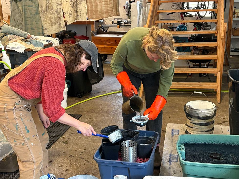
In Amenia this fall, three artists came together to experiment with an ancient process — extracting blue pigment from freshly harvested Japanese indigo. What began as a simple offer from a Massachusetts farmer to share her surplus crop became a collaborative exploration of chemistry, ecology and the art of making by hand.
“Collaboration is part of our DNA as people who work with textiles,” said Amenia-based artist Christy Gast as she welcomed me into her vast studio. “The whole history of every part of textile production has to do with cooperation and collaboration,” she continued.
That sense of shared purpose is at the heart of the invitation Gast extended to artists Natalie Baxter and Janis Stemmermann to process a bumper crop of Japanese indigo (Persicaria tinctoria) at her studio this fall. All three artists’ practices intersect through material, process and an interest in the handmade. Gast and Stemmermann have collaborated on a series of hand-knit vests dyed with black walnut, available through Stemmermann’s store, Russell Janis. Baxter is a Wassaic Project residency and fellowship alum, who is leading a community quilting workshop there on Nov. 15. She also co-directs “Cottage Courses” with artist Polly Shindler, a series of hands-on artmaking workshops throughout the region.
“Lisa Dachinger of Hilltop Farm & Fiber Arts north of Pittsfield, Massachusetts had an abundance of indigo this year,” said Gast of her learning about the crop’s availability.In two trips to the farm, Gast harvested the plants and began experimenting with the ancient art and science of extracting pigment from the plants and transforming it into rich, layered blues.

“There are a lot of steps,” Gast noted with a laugh, as vats of aerated indigo bubbled in the corner of the studio. The process is slow and physical, dependent on timing, temperature and a kind of faith in chemistry. The freshly harvested Japanese indigo leaves are first soaked in warm water and left to ferment for several days. The plant matter is then removed, the solution is strained and the pH is raised with the addition of calcium hydroxide, and then the mixture is aerated, poured back and forth between containers until it oxidizes and the pigment turns dark blue. After the indigo settles to the bottom, the resulting paste is filtered, dried and ground into powder. Only then is it ready for dyeing.
But as Stemmermann pointed out, “It’s not a dye. It’s a coating and reaction.” Indigo’s elusive chemistry means each piece is unpredictable, shaped as much by chance as by control. To achieve a deep, saturated blue, “you have to layer it and dip it up to eight times,” she explained.
Each artist uses dye in their work, albeit quite differently, yet all share a deep sensitivity to material and process. “There is a seasonality to textile work,” said Baxter, referring to dye plants.“First, there’s the planting. And then you wait for them to grow, you harvest them, you dye the fabric and then it’s wintertime.” During quilt season when our attention turns inward, the patient, hands-on process becomes a meditation on slowness for Baxter, mirroring the rhythm of the earth and a quiet longing to move with it.

For Gast, working with plant dyes is a way to align artistic practice with ecology and activism. “I’m working on a project that will be showing at Mass MoCA in 2027,” she explained. “It’s a collaborative opera about peatlands for which I’m producing a textile installation that functions as the curtains. I’m using as many natural and regional processes as possible because our work has to do with local-to-global activism and conservation. There is a chemical alchemy in peatlands, which despite covering just 3% of the Earth’s surface, capture more than twice the carbon of all the planet’s forests combined. There’s a direct poetic alignment between plant dye processes and peatlands, which preserved some of the earliest textiles we know of. And the color palette is ancient, both familiar and uncanny.”
There’s a certain chaos in balancing experimentation with intent. For Gast, Baxter, and Stemmermann, this first attempt at pigment extraction has been as much about curiosity as outcome, a communal act of making, rooted in patience, experimentation and discovery.
To find out more about these artists, visit: christygast.com, nataliebaxter.com and janisstemmermann.com
Keep ReadingShow less
loading


